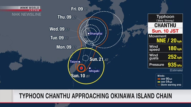
Typhoon Chanthu approaching Okinawa island chain
Typhoon
Chanthu is approaching the Yaeyama region of Okinawa Prefecture, southwestern
Japan.
Japan's
Meteorological Agency says the typhoon was moving north at about 20 kilometers
per hour as of 7:00 a.m. on Sunday, Japan time.
It has a
central atmospheric pressure of 935 hectopascals, and central winds of 180
kilometers per hour, with gusts up to 252 kilometers per hour.
The typhoon
is likely to continue moving north and approach the Sakishima Island chain in
Okinawa Prefecture on Sunday afternoon to evening while retaining its power.
The agency
is advising people in the region to be on high alert for violent winds.
Vigorous
winds of up to 162 kilometers per hour are forecast for the Yaeyama region,
including the islands of Yonaguni and Ishigaki, shortly after midday on Sunday.
Maximum gusts of 234 kilometers per hour are expected.
The agency
is advising people in the region to evacuate to strong buildings before stormy
winds begin to blow, and stay indoors away from windows.
It says in
past typhoons of this level, winds knocked down utility poles and concrete
block walls, and turned vehicles on their sides.
Rough seas
are already visible in the Yaeyama region and waves will likely be as high as
ten meters shortly before midday.
Clouds from
the typhoon are beginning to shroud the area, bringing intermittent but heavy
rain.
As more developed clouds cover the region, extreme rain with thunder is
expected.
Over the 24
hours until Monday morning, 180 millimeters of rain will fall in the Yaeyama
region.
Caution is also advised for possible lightning strikes and
gusty winds.
https://www3.nhk.or.jp/nhkworld/en/news/


Yorumlar
Yorum Gönder